INSEE’s premises
[1]:
import geopandas
import re
import pandas as pd

%matplotlib inline
import matplotlib.pyplot as plt
import matplotlib.patches as mpatches
import matplotlib, descartes

from pynsee.sirene import search_sirene
from pynsee.geodata import get_geodata_list, get_geodata
/usr/local/lib/python3.12/site-packages/tqdm/auto.py:21: TqdmWarning: IProgress not found. Please update jupyter and ipywidgets. See https://ipywidgets.readthedocs.io/en/stable/user_install.html
  from .autonotebook import tqdm as notebook_tqdm
[2]:
import logging
import sys
logging.basicConfig(stream=sys.stdout,
                    level=logging.INFO,
                    format="%(message)s")
Subscribe to api.insee.fr and get your credentials!
Save your credentials with init_conn function :
from pynsee.utils import init_conn
init_conn(sirene_key="my_sirene_key")
Beware : any change to the keys should be tested after having cleared the cache
Please do :
from pynsee.utils import clear_all_cache; clear_all_cache()[3]:
import os
os.environ['sirene_key'] = "f7345356-8301-4567-b453-568301456723"
[4]:
variable = ["denominationUniteLegale", 'sigleUniteLegale', 'categorieJuridiqueUniteLegale']

insee_pattern = "INSTITUT NATIONAL DE LA STATISTIQUE ET DES ETUDES ECONOMIQUES"

pattern = [insee_pattern, 'INSEE', '7120']
# 7120 : Service central d'un ministère

data = search_sirene(variable = variable, pattern = pattern, kind="siret")
Previously saved data has been used:
/home/onyxia/.cache/pynsee/pynsee/acaae682614742b3fc8d1b32c8e57c06.parquet
Creation date: 2025-06-28, today
Set update=True to get the most up-to-date data
[5]:
gdf = data.get_location()
This function returns data made available by OpenStreetMap and its contributors.
Please comply with Openstreetmap's Copyright and ODbL Licence
INSEE API credentials have not been found: please try to reuse pynsee.init_conn to save them locally.
Otherwise, you can still use environment variables as follow:

import os
os.environ['sirene_key'] = 'my_sirene_key'
Existing environment variable sirene_key used, instead of locally saved credentials
Getting location: 0%| | 0/32 [00:00<?, ?it/s]
Previously saved data has been used:
/home/onyxia/.cache/pynsee/pynsee/6b05d2e8cf8de48b5a73c9a400c8c4c1.json
Set update=True to get the most up-to-date data
Previously saved data has been used:
/home/onyxia/.cache/pynsee/pynsee/b8a82eb66c63b83c98f2e2a4bf25bc11.json
Set update=True to get the most up-to-date data
Previously saved data has been used:
/home/onyxia/.cache/pynsee/pynsee/8f30fd18cb688dafa93fe22a82443ade.json
Set update=True to get the most up-to-date data
Previously saved data has been used:
/home/onyxia/.cache/pynsee/pynsee/50abc53ac9ba98eabaed84a40aa7ca8e.json
Set update=True to get the most up-to-date data
Previously saved data has been used:
/home/onyxia/.cache/pynsee/pynsee/8f614709b2a3e103afda2454a5678ab6.json
Set update=True to get the most up-to-date data
Previously saved data has been used:
/home/onyxia/.cache/pynsee/pynsee/bf44d6f7f8d1c27ae4efdb0ae7a239dd.json
Set update=True to get the most up-to-date data
Previously saved data has been used:
/home/onyxia/.cache/pynsee/pynsee/31b39d7e833eefa400581c6ba71cb447.json
Set update=True to get the most up-to-date data
Previously saved data has been used:
/home/onyxia/.cache/pynsee/pynsee/89a67ed79b14d5183feaae31d4d767c5.json
Set update=True to get the most up-to-date data
Previously saved data has been used:
/home/onyxia/.cache/pynsee/pynsee/a1f7fc6de16cbf525641ddc6e13f1b5f.json
Set update=True to get the most up-to-date data
Previously saved data has been used:
/home/onyxia/.cache/pynsee/pynsee/5faf9447c506b220c2cba72c480c98e8.json
Set update=True to get the most up-to-date data
Previously saved data has been used:
/home/onyxia/.cache/pynsee/pynsee/717dd9025eb4719fe9610d7129df43f0.json
Set update=True to get the most up-to-date data
Previously saved data has been used:
/home/onyxia/.cache/pynsee/pynsee/df676ca37c304dddba4f422f8edbbb7e.json
Set update=True to get the most up-to-date data
Previously saved data has been used:
/home/onyxia/.cache/pynsee/pynsee/a9a8c3d2c93133cca8d1f469fdd0486f.json
Set update=True to get the most up-to-date data
Previously saved data has been used:
/home/onyxia/.cache/pynsee/pynsee/f107a9122f02b785cfe6735b7c1379d6.json
Set update=True to get the most up-to-date data
Previously saved data has been used:
/home/onyxia/.cache/pynsee/pynsee/bf29cb16ce2c18b0c3bafb12591fbb06.json
Set update=True to get the most up-to-date data
Previously saved data has been used:
/home/onyxia/.cache/pynsee/pynsee/762bbc311d97cf3946f0339fc36b296c.json
Set update=True to get the most up-to-date data
Previously saved data has been used:
/home/onyxia/.cache/pynsee/pynsee/5626619af34d1fefe798615ef5a667b7.json
Set update=True to get the most up-to-date data
Previously saved data has been used:
/home/onyxia/.cache/pynsee/pynsee/389bc20b0bb00d25ebe79548de02796b.json
Set update=True to get the most up-to-date data
Previously saved data has been used:
/home/onyxia/.cache/pynsee/pynsee/0bac0871892bb556c48ff964d34f20fb.json
Set update=True to get the most up-to-date data
Previously saved data has been used:
/home/onyxia/.cache/pynsee/pynsee/3655a69ebe64cbeea6344a886fdd8635.json
Set update=True to get the most up-to-date data
Previously saved data has been used:
/home/onyxia/.cache/pynsee/pynsee/46117914b0804652787d9b7d72a45bf7.json
Set update=True to get the most up-to-date data
Previously saved data has been used:
/home/onyxia/.cache/pynsee/pynsee/33a6a6bca537cf561fc93826f1001a99.json
Set update=True to get the most up-to-date data
Previously saved data has been used:
/home/onyxia/.cache/pynsee/pynsee/ae15ee9ca6adea71ba65a5b79b7d8455.json
Set update=True to get the most up-to-date data
Previously saved data has been used:
/home/onyxia/.cache/pynsee/pynsee/0257ca28cbbc2dae2ef8f2df77ab8c3c.json
Set update=True to get the most up-to-date data
Previously saved data has been used:
/home/onyxia/.cache/pynsee/pynsee/921feff526c6552202bcd6277ff149a7.json
Set update=True to get the most up-to-date data
Previously saved data has been used:
/home/onyxia/.cache/pynsee/pynsee/48be8843ad1a68a69116880ce0338f06.json
Set update=True to get the most up-to-date data
Previously saved data has been used:
/home/onyxia/.cache/pynsee/pynsee/00a74dfb427c73250ad673aecca2ca60.json
Set update=True to get the most up-to-date data
Previously saved data has been used:
/home/onyxia/.cache/pynsee/pynsee/7d1ccd74a8d87908fae0624b8968ad64.json
Set update=True to get the most up-to-date data
Previously saved data has been used:
/home/onyxia/.cache/pynsee/pynsee/ed72fdfe535f40fff903f1443090787e.json
Set update=True to get the most up-to-date data
Previously saved data has been used:
/home/onyxia/.cache/pynsee/pynsee/7fb87565654627619a206fa33789162b.json
Set update=True to get the most up-to-date data
Previously saved data has been used:
/home/onyxia/.cache/pynsee/pynsee/e2f5fbd0576802d9c22f655f502a0843.json
Set update=True to get the most up-to-date data
Previously saved data has been used:
/home/onyxia/.cache/pynsee/pynsee/7f2b603e6a7eadc11c89407fbf635dc6.json
Set update=True to get the most up-to-date data
Getting location: 100%|██████████| 32/32 [00:00<00:00, 1292.07it/s]
Getting location:   0%|          | 0/3 [00:00<?, ?it/s]
Previously saved data has been used:
/home/onyxia/.cache/pynsee/pynsee/76ce91da17c666e71b9ba4ad4020629d.json
Set update=True to get the most up-to-date data
Previously saved data has been used:
/home/onyxia/.cache/pynsee/pynsee/f224a1c88bd3afe1d2def2af095851ab.json
Set update=True to get the most up-to-date data
Previously saved data has been used:
/home/onyxia/.cache/pynsee/pynsee/952870fe54e1acc305187a4692b985e6.json
Set update=True to get the most up-to-date data
Getting location: 100%|██████████| 3/3 [00:00<00:00, 1585.35it/s]
[6]:
# move overseas departement closer to metropolitan France
gdf = gdf.transform_overseas().zoom()
Converting GeoDataFrame to EPSG:3857.
Previously saved data has been used:
/home/onyxia/.cache/pynsee/pynsee/f2bbdea5546ef02791b1286f1b6b1a51.parquet
Creation date: 2025-06-28, today
Set update=True to get the most up-to-date data
Finding departement: 100%|██████████| 32/32 [00:00<00:00, 1051.00it/s]
NR is missing from code_insee_du_departement column !
[7]:
for i, row in gdf.iterrows():
    gdf.loc[i, 'name'] = str(i + 1) + ' - ' + row.enseigne1Etablissement
    gdf.loc[i, 'i'] = i + 1

# cleaning
gdf = gdf[~gdf.geometry.isnull()]
[8]:
geodataList =  get_geodata_list()
mapdep = get_geodata('ADMINEXPRESS-COG-CARTO.LATEST:departement')

# move overseas departement closer to metropolitan France
# add a zoom on ile de France region
mapdep = mapdep.transform_overseas().zoom()
mapdep.head()
Previously saved data has been used:
/home/onyxia/.cache/pynsee/pynsee/e879822687bab4b12f23762b5d56742b.parquet
Creation date: 2025-06-28, today
Set update=True to get the most up-to-date data
Previously saved data has been used:
/home/onyxia/.cache/pynsee/pynsee/7a91d3072047b4ad17253bc108ef87cf.parquet
Creation date: 2025-06-28, today
Set update=True to get the most up-to-date data
NR is missing from code_insee_du_departement column !
[8]:
| geometry | cleabs | nom_officiel | nom_officiel_en_majuscules | code_insee | code_insee_de_la_region | code_siren | code_insee_du_departement | |
|---|---|---|---|---|---|---|---|---|
| 0 | MULTIPOLYGON (((277926.054 5709617.925, 277848... | DEPARTEM0000000000000063 | Puy-de-Dôme | PUY-DE-DOME | 63 | 84 | 226300010 | 63 |
| 1 | MULTIPOLYGON (((336295.261 6472777.256, 336428... | DEPARTEM0000000000000059 | Nord | NORD | 59 | 32 | 225900018 | 59 |
| 2 | MULTIPOLYGON (((-91403.654 6186431.719, -91543... | DEPARTEM0000000000000061 | Orne | ORNE | 61 | 28 | 226100014 | 61 |
| 3 | MULTIPOLYGON (((582085.39 5342294.655, 582092.... | DEPARTEM0000000000000013 | Bouches-du-Rhône | BOUCHES-DU-RHONE | 13 | 93 | 221300015 | 13 |
| 4 | MULTIPOLYGON (((259950.061 6258104.764, 260905... | DEPARTEM0000000000000075 | Paris | PARIS | 75 | 11 | 227500055 | 75 |
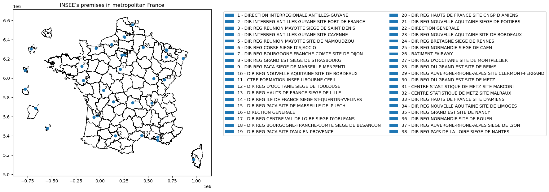
[9]:
# plot
ax = mapdep.plot(color='white', edgecolor='black', figsize = (15,7))

gdf.plot(ax=ax)
plt.title("INSEE's premises in metropolitan France")

for x, y, i, label in zip(gdf.geometry.x, gdf.geometry.y, gdf.i, gdf.name):
    ax.annotate(int(i), xy=(x, y), xytext=(4, 4), textcoords="offset points",
                bbox=dict(boxstyle='square,pad=0', fc="#ffffffb0", ec='none'))

legends = [mpatches.Patch(label=f) for f in gdf.name]
plt.legend(handles=legends, ncol=2, bbox_to_anchor=(1.05, 1))
plt.show()